![[internet geography]](../images/pagelayout/netgeologo.gif)
![]()
Physical Geography
Coasts
Earthquake
Ecosystems
Glaciation
Limestone
Plate Tectonics
Rivers
Volcanoes
Weather and climate
National Parks
Human Geography
Landuse
Migration
Urbanisation
Economic Geography

|
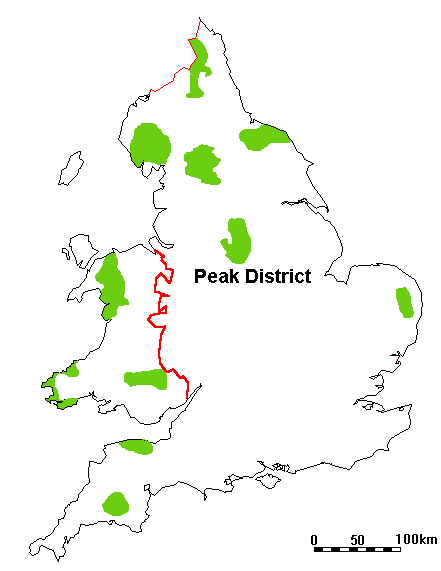
Castleton - A honey pot in the Peak District
|
|
Castleton is located in the Peak District National Park.
Castleton lies towards the north of the National Park. It is 10 miles from Buxton, 16 miles from Sheffield and 27 miles from Stockport. Half of the population of England live within 60 miles of the Peak Park.
What are Castleton's attractions?
![[Castleton and surrounding area]](../images/castleton.gif) Image produced from the Ordnance Survey Get-a-map service. Image reproduced with kind permission of Ordnance Survey and Multi Media Mapping. Castleton has many human and natural attractions. These include:
What problems do tourists cause around Castleton?
Castleton is a one of the Peak Districts most popular honey pots. Honeypots are areas which attract many tourists. They are so called because tourists flock to these places like 'bees around honey'. Castleton recieves over 2 million visitors every year. This large number of tourist causes many problems in and around Castleton. These problems include include -
How are these problems being tackled?
Footpath erosion - Improvements such as surfacing paths in local stone or re-routing certain paths have been undertaken to reduce the impact of erosion. An increasing number of litter bins have been provided throughout the village.
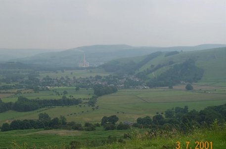
What problems are caused by industry in the area? There is a cement works located to the south east of Castleton. It uses limestone quarried nearby. The works causes a number of problems. Firstly is spoils the attractive view from the top of Mam Tor. This is a form of visual pollution. Click here to see a photograph of the view. Noise from the trucks moving between the works and the quarry causes noise pollution. Dust is blown from the works and trucks. What benefits are created by industry in the area? Social Benefits:
Economic Benefits:
|
![[honey pot - where tourist swarm like bees around honey!]](../images/castleton/honeypot.gif)
![]()
GeoNet is not responsible for the content of any of these sites
The Peak District National Park - Castleton - A Tourist Village?
Cross Street (Castleton's main street) with Mam Tor in the background.
![]()
Cross Street
![[Enterance to the Peak Cavern]](../images/castleton/peakcavern.jpg)
The entrance to Peak Cavern.
![]()
A view of Pevril
Castle from Castle Street
A view of the Hope Valley from the top of Mam Tor. Notice the cement works in the background.
![]()
Cement Factory in the Hope Valley
![]()
A view from Winnats Pass out onto the Hope Valley
![]()
Speedwell Cavern