![[internet geography]](../images/pagelayout/netgeologo.gif)
![]()
Physical Geography
Coasts
Earthquake
Ecosystems
Glaciation
Limestone
Plate Tectonics
Rivers
Volcanoes
Weather and climate
National Parks
Human Geography
Landuse
Migration
Urbanisation
Economic Geography

|
The area known as Spurn forms the southern extremity of the Holderness coast and includes the unique feature of Spurn Head, a sand and shingle spit 5.5km long, reaching across the mouth of the Humber. Spurn is made up of the material which has been transported along the Holderness Coast. This includes sand, sediment and shingle.
Spurn
Head is an example of a feature geographers call a spit.
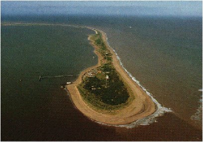
(This is an aerial photograph of Spurn Head. It has been kindly donated by the Yorkshire Wildlife Trust . Copyright is owned by the Trust) The spit forms a sweeping curve which continues the line of the coast. The sand which forms the spit has been transported along the Holderness Coast by longshore drift. The energy in the waves transporting the material reduces where the North Sea meets the Humber Estuary. As a result the material is deposited. This process is known as deposition.
|
![]()
GeoNet is not responsible for the content of any of these sites